Plans and maps of St. Petersburg of the 18th-19th centuries
25.05.2020 10:36
25.05.2020 10:36
Andrey Panevin

Settlements of Novgorodians on the site of St. Petersburg existed until 1703, before the founding of the Northern Capital, which was preserved in the city toponomy: Kolomna, Avtovo.
St. Petersburg existed until 1703, before the founding of the Northern Capital, which was preserved in the city toponomy: Kolomna, Avtovo.
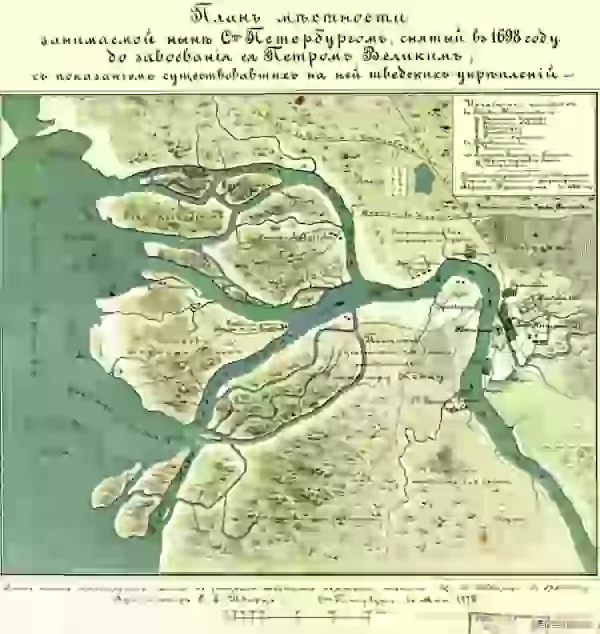
1698 year

The city of Nien and the Swedish fortress Nyenskans. Peter I ordered to destroy this fortress, and to lay a new one closer to the bay on Hare Island.
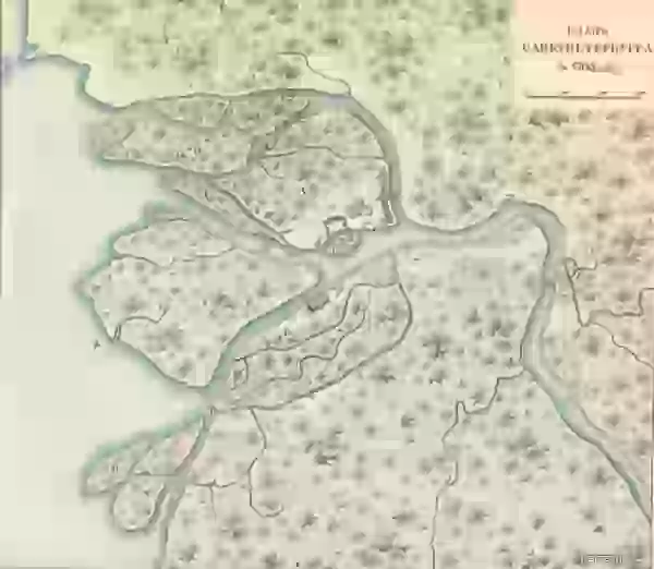
Plan of St. Petersburg, 1705 year. Nevsky Prospect does not yet exist, but the first city buildings have already been mapped. There is also the Novgorod tract and the path to the Winter Palace and the Admiralty along the banks of the Neva .
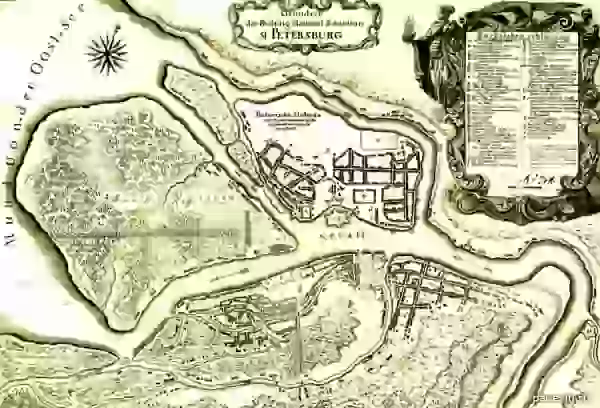
Plan of St. Petersburg 1710s. From the collection of the Stockholm Royal Military Archives
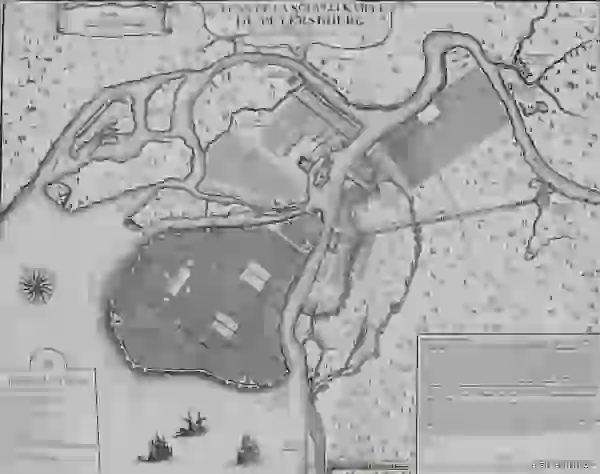
Map of St. Petersburg compiled in 1717 by Nicolas de Fer. The border of the city is Moika, between Moika and Fontanka has not yet been built up.

Saint Petersburg map. 1720 year.
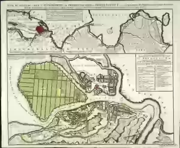
Saint Petersburg map. 1725 year. Saint Petersburg map.
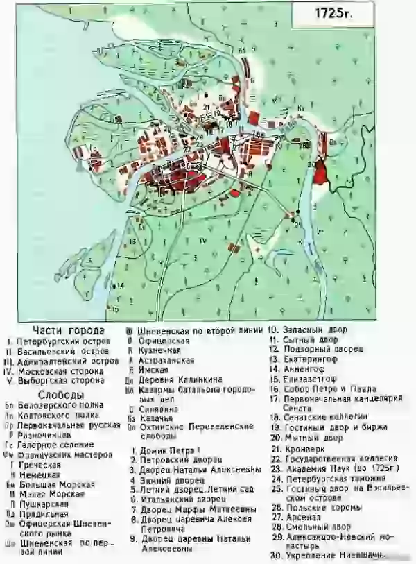
1725 year. Saint Petersburg map.
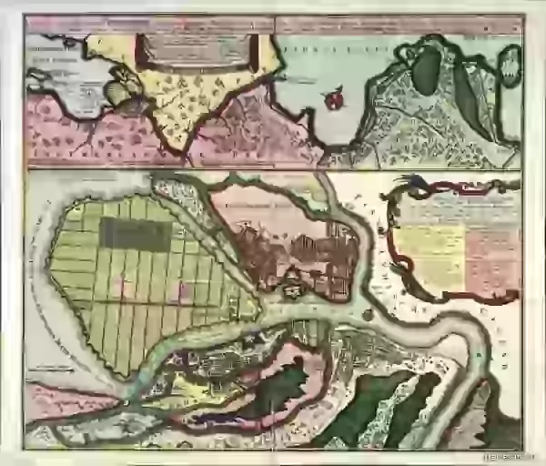
1730 year. The way Vasilievsky Island is "lined" - these are plans, they will be embodied in a slightly different form. Saint Petersburg map.
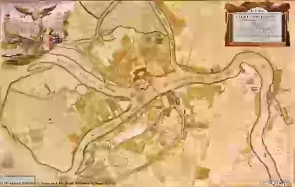
1737 year. The area between Moika and Fontanka is inhabited, but it continues to be so deserted that Pastor Kreutz, in his petition to the Empress Anna Ioannovna, pointed out: “I am afraid of a lack of water, intruders, murderers, thieves and various vicissitudes that usually happen to those who live far away from their neighbors. "
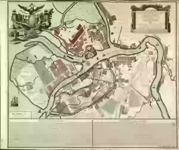
1744, topographic map of Petropolis (yes, this name was also used). From the middle of the 18th century, Fontanka became the border of the city . Fragment of the "Plan of the capital city of St. Petersburg with the image of the most notable avenues thereof." Compiled by I.F.Truskott and others, engravers I. Sokolov and others, artist M.I.Makhaev (St. Petersburg, 1753
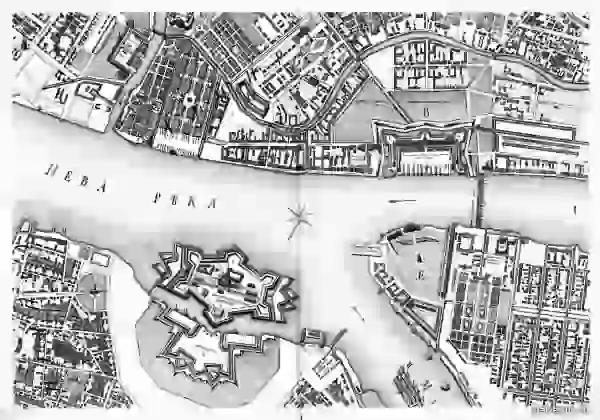
1753 year). The defensive fortifications and ditches around the Admiralty are clearly visible, it was immediately planned not only as a shipyard, but also as a fortress blocking the passage of Swedish ships to the fortress of St. Petersburg. The Swedes didn't bother. The fortifications will be finally removed and the ditches will be filled in a century later, when the Alexander Gardens will be laid out on the esplanade in front of the Admiralty under the leadership of Karl Rossi and the surrounding area will be ennobled. Also noteworthy is the pontoon Isaakievsky bridge, built during navigation.
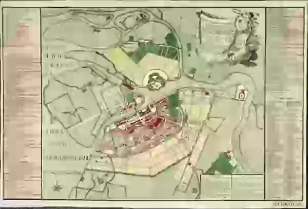
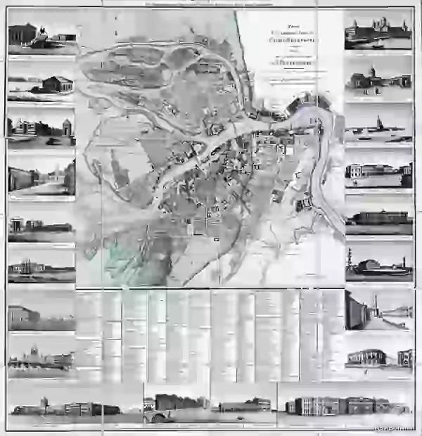
1825 year Neva although it is indicated, it is not permanent, but floating. Isaac's Cathedral is still the previous one - the third, and the Admiralty and Kazan Cathedral are already present and the construction of the Exchange completed the Strelka ensemble of Vasilyevsky Island . The Smolny Cathedral already exists, but it will be completed and consecrated in 10 years, in 1835 .
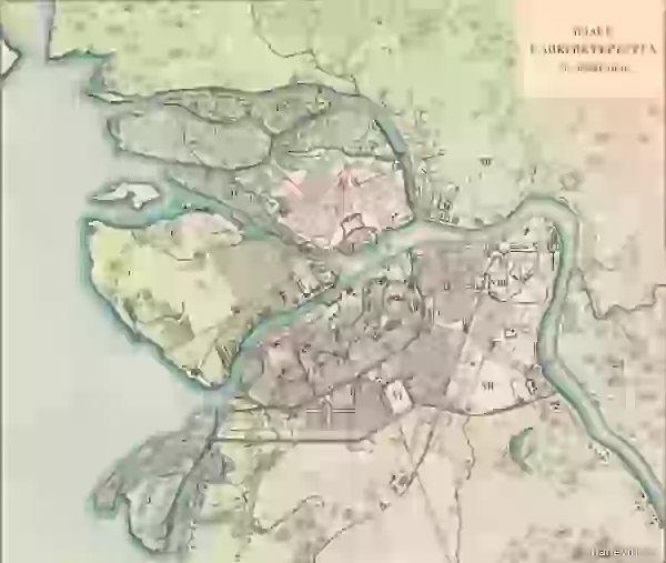
The year is 1776 . New plan of the capital city and the fortress of St. Petersburg. Plan of the capital city of St. Petersburg. Engraver A. Savinkov (St. Petersburg, 1825 ). Liteiny bridge across the Neva
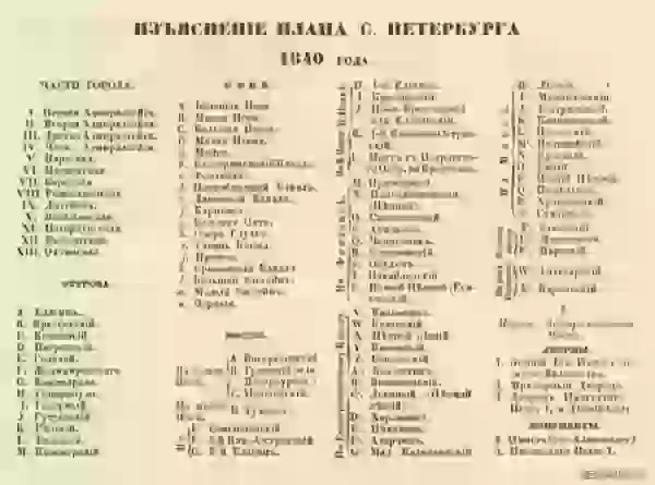
Saint Petersburg map. 1840 year. Notable changes - the Obvodny Canal appeared on the map, opened for shipping in 1835. Saint Petersburg map. 1840, legend 1. Map of St. Petersburg. 1840, legend 2.
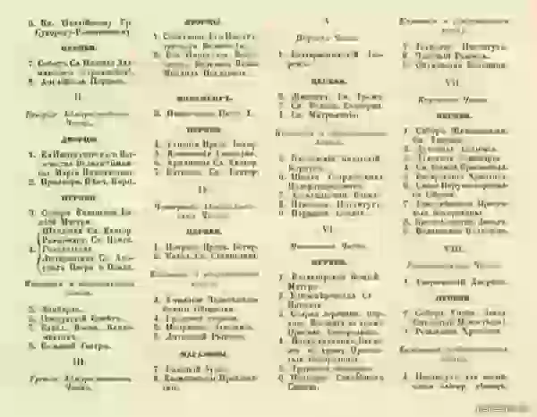
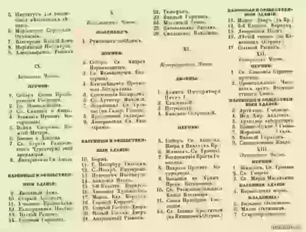
Saint Petersburg map. 1840, legend 3.
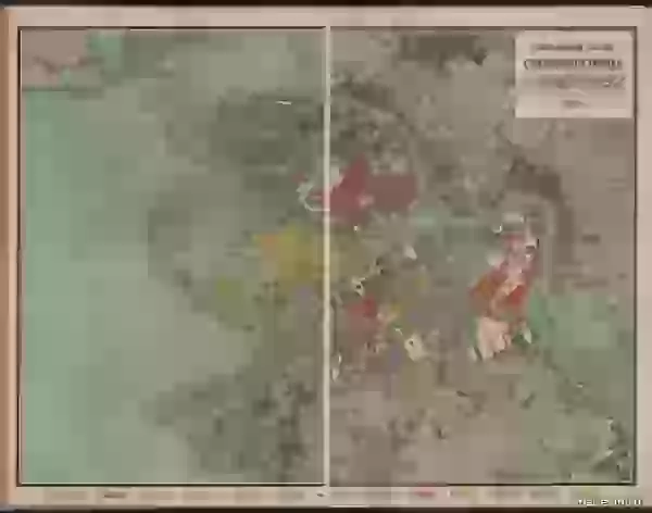
Map of St. Petersburg. 1858 year.

Map of St. Petersburg. 1858, explanations of the plan.
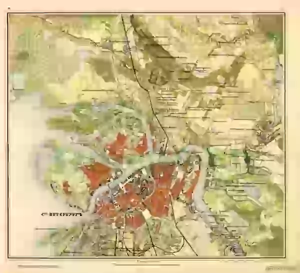
Saint Petersburg map. 1859 year. Troitsky and Dvortsovy bridges, which will be built in 1903 and 1917, respectively, are surprising.
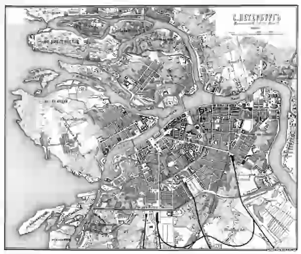
From the Guide to Russian Railways, 1867 . 1893 year. There is already a permanent Liteiny Bridge, opened in 1879.
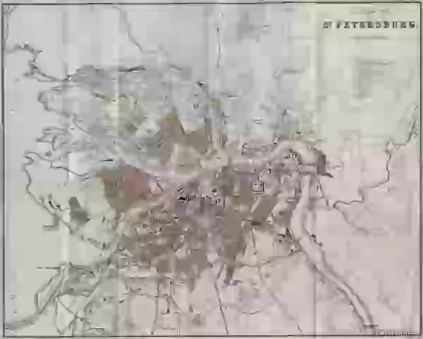
1898 year.
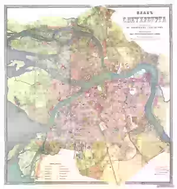
1898
Bonus XX century and modernity:
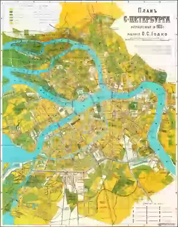
1903.
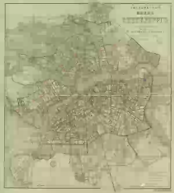
1904 year.
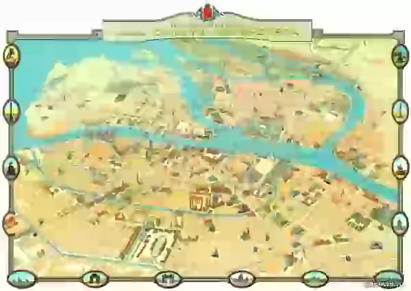
Taxi plan 1913 year. There are already permanent bridges across the Neva: Liteiny, Blagoveshchensky, Troitsky, but the Palace is not yet, it will begin to be built in the next 1914, and instead of it there is still a pontoon Isaac Bridge (from Senate Square to Vasilyevsky Island ).
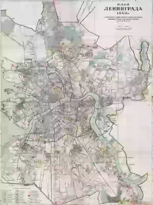
1940 year.
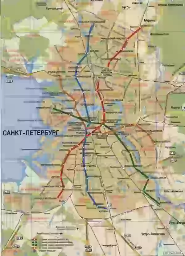
A modern map, well, almost.Settlements of Novgorodians on the site of St. Petersburg existed until 1703, before the founding of the Northern Capital, which was preserved in the city toponomy: Kolomna, Avtovo.

1698 year

The city of Nien and the Swedish fortress Nyenskans. Peter I ordered to destroy this fortress, and to lay a new one closer to the bay on Hare Island.

Plan of St. Petersburg, 1705 year. Nevsky Prospect does not yet exist, but the first city buildings have already been mapped. There is also the Novgorod tract and the path to the Winter Palace and the Admiralty along the banks of the Neva .

Plan of St. Petersburg 1710s. From the collection of the Stockholm Royal Military Archives

Map of St. Petersburg compiled in 1717 by Nicolas de Fer. The border of the city is Moika, between Moika and Fontanka has not yet been built up.

Saint Petersburg map. 1720 year.

Saint Petersburg map. 1725 year. Saint Petersburg map.

1725 year. Saint Petersburg map.

1730 year. The way Vasilievsky Island is "lined" - these are plans, they will be embodied in a slightly different form. Saint Petersburg map.

1737 year. The area between Moika and Fontanka is inhabited, but it continues to be so deserted that Pastor Kreutz, in his petition to the Empress Anna Ioannovna, pointed out: “I am afraid of a lack of water, intruders, murderers, thieves and various vicissitudes that usually happen to those who live far away from their neighbors. "

1744, topographic map of Petropolis (yes, this name was also used). From the middle of the 18th century, Fontanka became the border of the city . Fragment of the "Plan of the capital city of St. Petersburg with the image of the most notable avenues thereof." Compiled by I.F.Truskott and others, engravers I. Sokolov and others, artist M.I.Makhaev (St. Petersburg, 1753

1753 year). The defensive fortifications and ditches around the Admiralty are clearly visible, it was immediately planned not only as a shipyard, but also as a fortress blocking the passage of Swedish ships to the fortress of St. Petersburg. The Swedes didn't bother. The fortifications will be finally removed and the ditches will be filled in a century later, when the Alexander Gardens will be laid out on the esplanade in front of the Admiralty under the leadership of Karl Rossi and the surrounding area will be ennobled. Also noteworthy is the pontoon Isaakievsky bridge, built during navigation.


1825 year Neva although it is indicated, it is not permanent, but floating. Isaac's Cathedral is still the previous one - the third, and the Admiralty and Kazan Cathedral are already present and the construction of the Exchange completed the Strelka ensemble of Vasilyevsky Island . The Smolny Cathedral already exists, but it will be completed and consecrated in 10 years, in 1835 .

The year is 1776 . New plan of the capital city and the fortress of St. Petersburg. Plan of the capital city of St. Petersburg. Engraver A. Savinkov (St. Petersburg, 1825 ). Liteiny bridge across the Neva

Saint Petersburg map. 1840 year. Notable changes - the Obvodny Canal appeared on the map, opened for shipping in 1835. Saint Petersburg map. 1840, legend 1. Map of St. Petersburg. 1840, legend 2.


Saint Petersburg map. 1840, legend 3.

Map of St. Petersburg. 1858 year.

Map of St. Petersburg. 1858, explanations of the plan.

Saint Petersburg map. 1859 year. Troitsky and Dvortsovy bridges, which will be built in 1903 and 1917, respectively, are surprising.

From the Guide to Russian Railways, 1867 . 1893 year. There is already a permanent Liteiny Bridge, opened in 1879.

1898 year.

1898
Bonus XX century and modernity:

1903.

1904 year.

Taxi plan 1913 year. There are already permanent bridges across the Neva: Liteiny, Blagoveshchensky, Troitsky, but the Palace is not yet, it will begin to be built in the next 1914, and instead of it there is still a pontoon Isaac Bridge (from Senate Square to Vasilyevsky Island ).

1940 year.

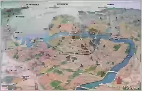
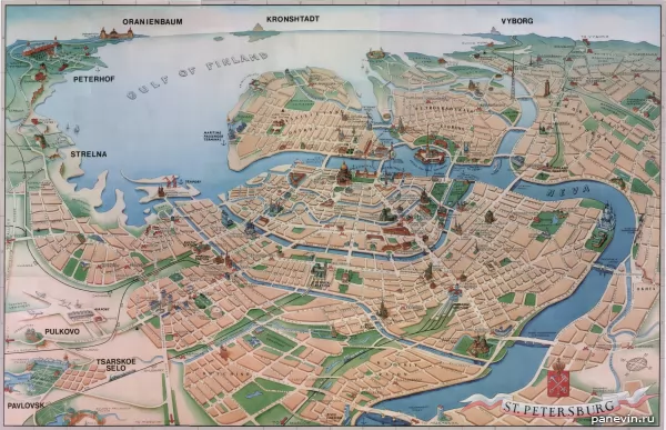
A modern map, well, almost. Several metro stations are missing. Axonometric plan with major points of interest.
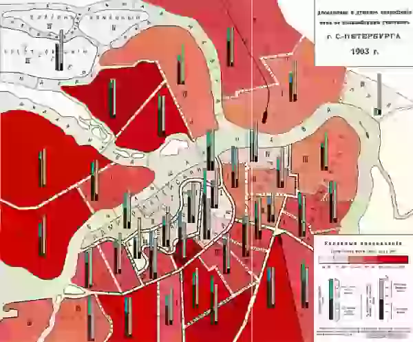
Absolute and per capita consumption of wine by police stations in St. Petersburg, 1903 .
Several metro stations are missing. Axonometric plan with major points of interest.


Absolute and per capita consumption of wine by police stations in St. Petersburg, 1903 .
t-peterburga_xviii-xix_1024-2.jpg" target="_blank">
1698 year

The city of Nien and the Swedish fortress Nyenskans. Peter I ordered to destroy this fortress, and to lay a new one closer to the bay on Hare Island.

Plan of St. Petersburg, 1705 year. Nevsky Prospect does not yet exist, but the first city buildings have already been mapped. There is also the Novgorod tract and the path to the Winter Palace and the Admiralty along the banks of the Neva .

Plan of St. Petersburg 1710s. From the collection of the Stockholm Royal Military Archives

Map of St. Petersburg compiled in 1717 by Nicolas de Fer. The border of the city is Moika, between Moika and Fontanka has not yet been built up.

Saint Petersburg map. 1720 year.

Saint Petersburg map. 1725 year. Saint Petersburg map.

1725 year. Saint Petersburg map.

1730 year. The way Vasilievsky Island is "lined" - these are plans, they will be embodied in a slightly different form. Saint Petersburg map.

1737 year. The area between Moika and Fontanka is inhabited, but it continues to be so deserted that Pastor Kreutz, in his petition to the Empress Anna Ioannovna, pointed out: “I am afraid of a lack of water, intruders, murderers, thieves and various vicissitudes that usually happen to those who live far away from their neighbors. "

1744, topographic map of Petropolis (yes, this name was also used). From the middle of the 18th century, Fontanka became the border of the city . Fragment of the "Plan of the capital city of St. Petersburg with the image of the most notable avenues thereof." Compiled by I.F.Truskott and others, engravers I. Sokolov and others, artist M.I.Makhaev (St. Petersburg, 1753

1753 year). The defensive fortifications and ditches around the Admiralty are clearly visible, it was immediately planned not only as a shipyard, but also as a fortress blocking the passage of Swedish ships to the fortress of St. Petersburg. The Swedes didn't bother. The fortifications will be finally removed and the ditches will be filled in a century later, when the Alexander Gardens will be laid out on the esplanade in front of the Admiralty under the leadership of Karl Rossi and the surrounding area will be ennobled. Also noteworthy is the pontoon Isaakievsky bridge, built during navigation.


1825 year Neva although it is indicated, it is not permanent, but floating. Isaac's Cathedral is still the previous one - the third, and the Admiralty and Kazan Cathedral are already present and the construction of the Exchange completed the Strelka ensemble of Vasilyevsky Island . The Smolny Cathedral already exists, but it will be completed and consecrated in 10 years, in 1835 .

The year is 1776 . New plan of the capital city and the fortress of St. Petersburg. Plan of the capital city of St. Petersburg. Engraver A. Savinkov (St. Petersburg, 1825 ). Liteiny bridge across the Neva

Saint Petersburg map. 1840 year. Notable changes - the Obvodny Canal appeared on the map, opened for shipping in 1835. Saint Petersburg map. 1840, legend 1. Map of St. Petersburg. 1840, legend 2.


Saint Petersburg map. 1840, legend 3.

Map of St. Petersburg. 1858 year.

Map of St. Petersburg. 1858, explanations of the plan.

Saint Petersburg map. 1859 year. Troitsky and Dvortsovy bridges, which will be built in 1903 and 1917, respectively, are surprising.

From the Guide to Russian Railways, 1867 . 1893 year. There is already a permanent Liteiny Bridge, opened in 1879.

1898 year.

1898
Bonus XX century and modernity:

1903.

1904 year.

Taxi plan 1913 year. There are already permanent bridges across the Neva: Liteiny, Blagoveshchensky, Troitsky, but the Palace is not yet, it will begin to be built in the next 1914, and instead of it there is still a pontoon Isaac Bridge (from Senate Square to Vasilyevsky Island ).

1940 year.

A modern map, well, almost. Several metro stations are missing. Axonometric plan with major points of interest.


Absolute and per capita consumption of wine by police stations in St. Petersburg, 1903 .
St. Petersburg existed until 1703, before the founding of the Northern Capital, which was preserved in the city toponomy: Kolomna, Avtovo.
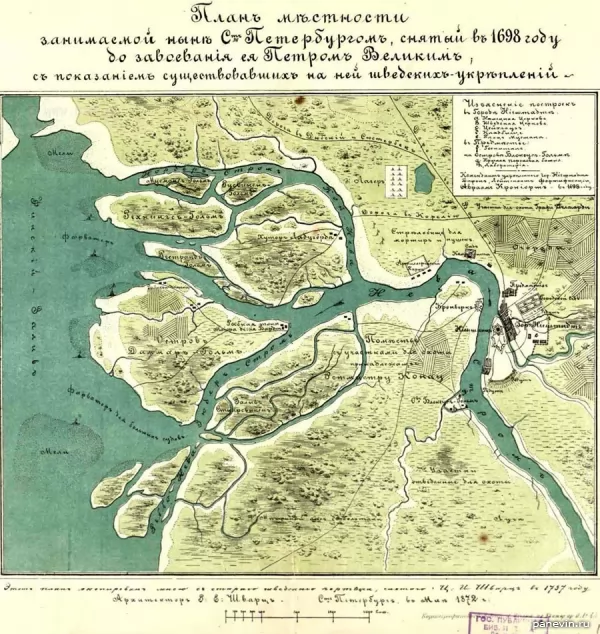
1698 year
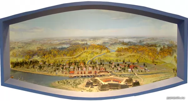
The city of Nien and the Swedish fortress Nyenskans. Peter I ordered to destroy this fortress, and to lay a new one closer to the bay on Hare Island.
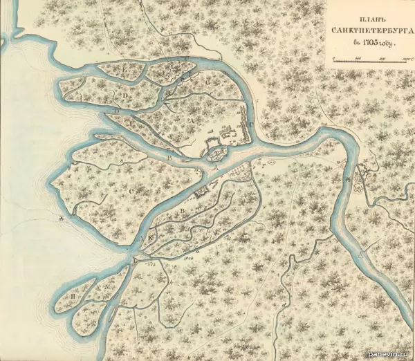
Plan of St. Petersburg, 1705 year. Nevsky Prospect does not yet exist, but the first city buildings have already been mapped. There is also the Novgorod tract and the path to the Winter Palace and the Admiralty along the banks of the Neva .
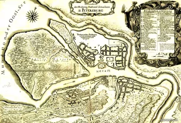
Plan of St. Petersburg 1710s. From the collection of the Stockholm Royal Military Archives
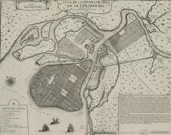
Map of St. Petersburg compiled in 1717 by Nicolas de Fer. The border of the city is Moika, between Moika and Fontanka has not yet been built up.
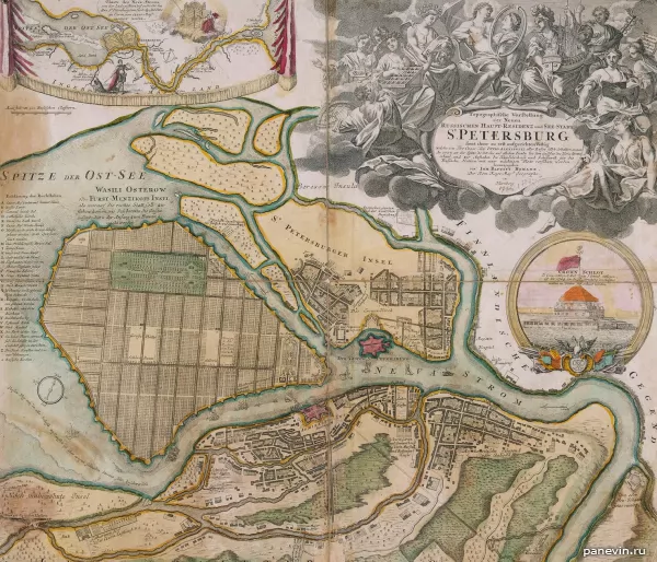
Saint Petersburg map. 1720 year.
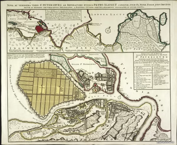
Saint Petersburg map. 1725 year. Saint Petersburg map.
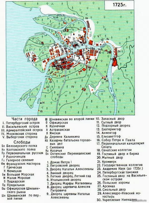
1725 year. Saint Petersburg map.
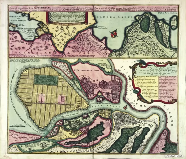
1730 year. The way Vasilievsky Island is "lined" - these are plans, they will be embodied in a slightly different form. Saint Petersburg map.
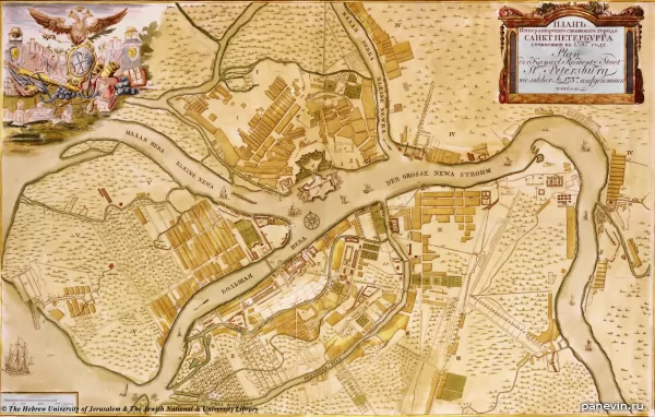
1737 year. The area between Moika and Fontanka is inhabited, but it continues to be so deserted that Pastor Kreutz, in his petition to the Empress Anna Ioannovna, pointed out: “I am afraid of a lack of water, intruders, murderers, thieves and various vicissitudes that usually happen to those who live far away from their neighbors. "
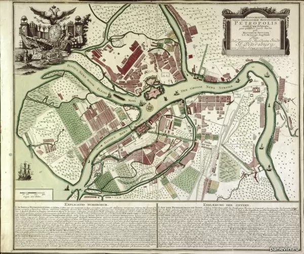
1744, topographic map of Petropolis (yes, this name was also used). From the middle of the 18th century, Fontanka became the border of the city . Fragment of the "Plan of the capital city of St. Petersburg with the image of the most notable avenues thereof." Compiled by I.F.Truskott and others, engravers I. Sokolov and others, artist M.I.Makhaev (St. Petersburg, 1753
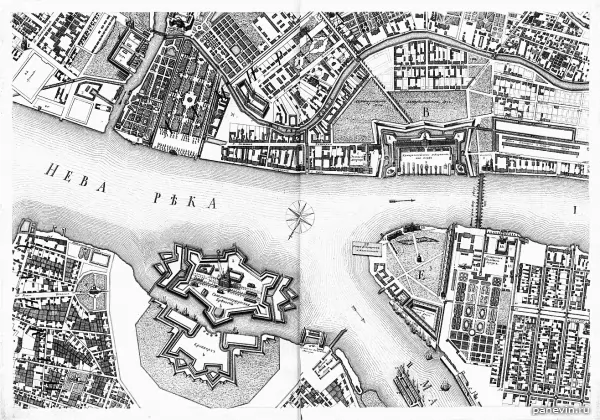
1753 year). The defensive fortifications and ditches around the Admiralty are clearly visible, it was immediately planned not only as a shipyard, but also as a fortress blocking the passage of Swedish ships to the fortress of St. Petersburg. The Swedes didn't bother. The fortifications will be finally removed and the ditches will be filled in a century later, when the Alexander Gardens will be laid out on the esplanade in front of the Admiralty under the leadership of Karl Rossi and the surrounding area will be ennobled. Also noteworthy is the pontoon Isaakievsky bridge, built during navigation.
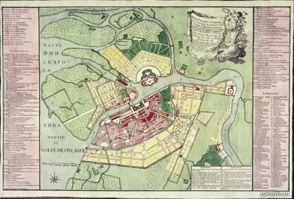
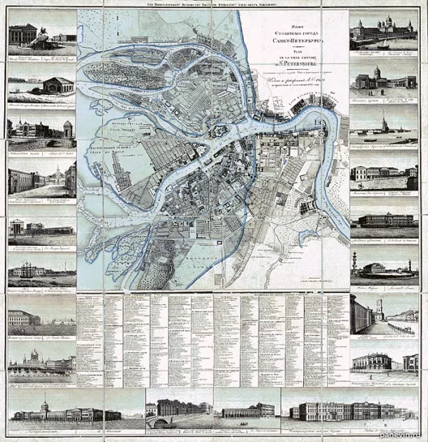
1825 year Neva although it is indicated, it is not permanent, but floating. Isaac's Cathedral is still the previous one - the third, and the Admiralty and Kazan Cathedral are already present and the construction of the Exchange completed the Strelka ensemble of Vasilyevsky Island . The Smolny Cathedral already exists, but it will be completed and consecrated in 10 years, in 1835 .
The year is 1776 . New plan of the capital city and the fortress of St. Petersburg. Plan of the capital city of St. Petersburg. Engraver A. Savinkov (St. Petersburg, 1825 ). Liteiny bridge across the Neva
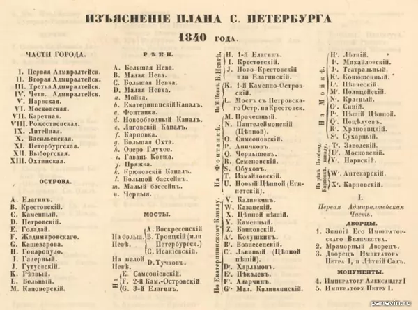
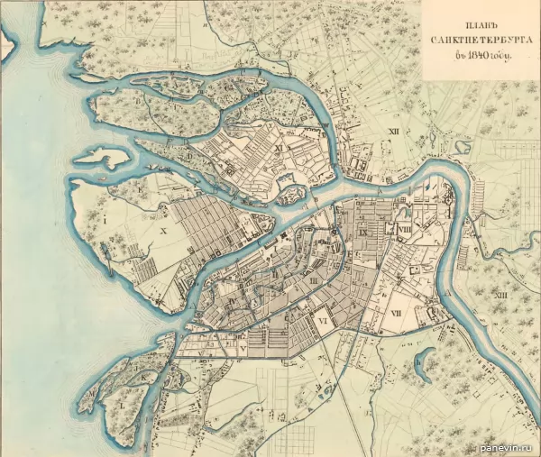
Saint Petersburg map. 1840 year. Notable changes - the Obvodny Canal appeared on the map, opened for shipping in 1835. Saint Petersburg map. 1840, legend 1. Map of St. Petersburg. 1840, legend 2.
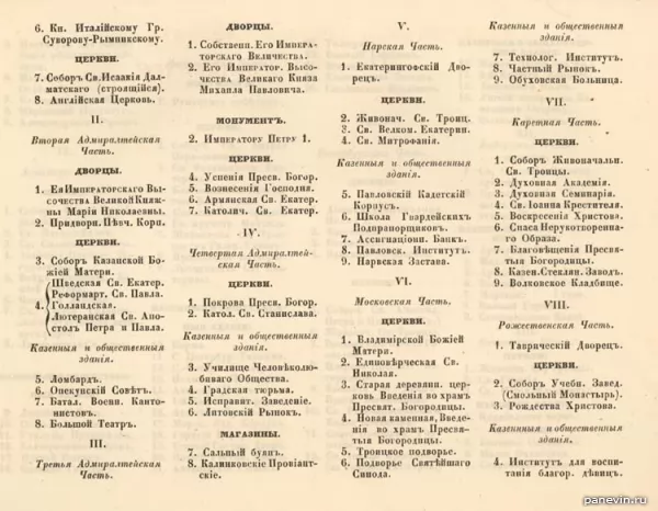
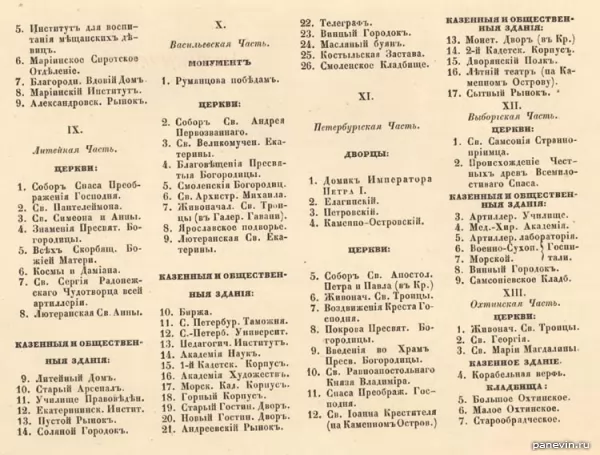
Saint Petersburg map. 1840, legend 3.
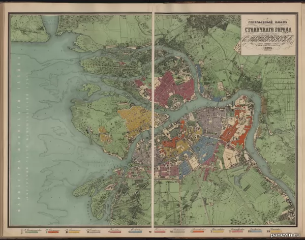
Map of St. Petersburg. 1858 year.
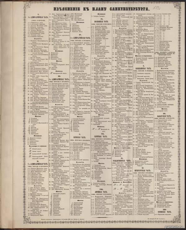
Map of St. Petersburg. 1858, explanations of the plan.
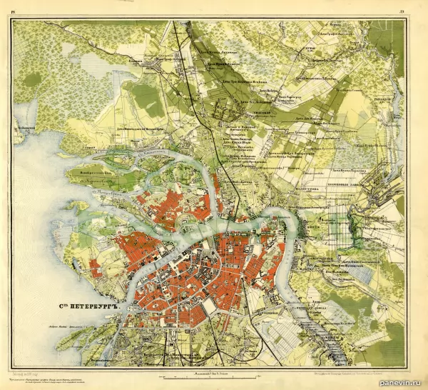
Saint Petersburg map. 1859 year. Troitsky and Dvortsovy bridges, which will be built in 1903 and 1917, respectively, are surprising.
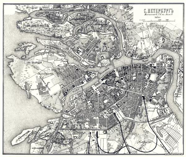
From the Guide to Russian Railways, 1867 . 1893 year. There is already a permanent Liteiny Bridge, opened in 1879.
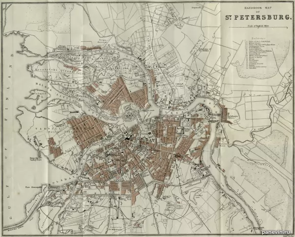
1898 year.
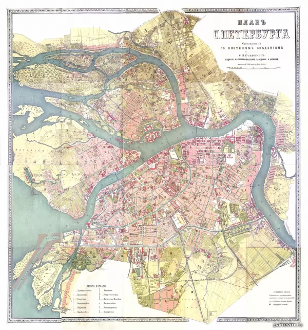
1898
Bonus XX century and modernity:
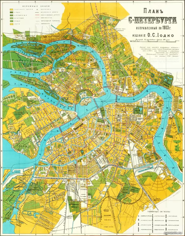
1903.
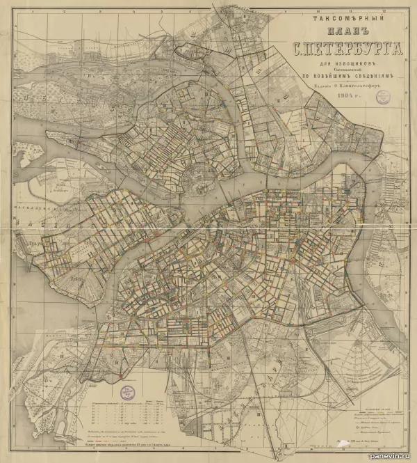
1904 year.

Taxi plan 1913 year. There are already permanent bridges across the Neva: Liteiny, Blagoveshchensky, Troitsky, but the Palace is not yet, it will begin to be built in the next 1914, and instead of it there is still a pontoon Isaac Bridge (from Senate Square to Vasilyevsky Island ).
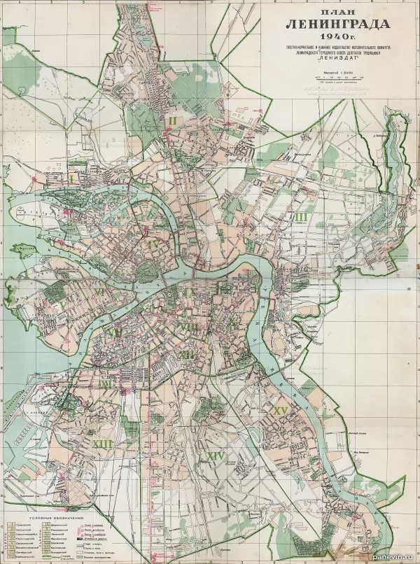
1940 year.
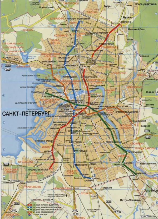
A modern map, well, almost.Settlements of Novgorodians on the site of St. Petersburg existed until 1703, before the founding of the Northern Capital, which was preserved in the city toponomy: Kolomna, Avtovo.

1698 year

The city of Nien and the Swedish fortress Nyenskans. Peter I ordered to destroy this fortress, and to lay a new one closer to the bay on Hare Island.

Plan of St. Petersburg, 1705 year. Nevsky Prospect does not yet exist, but the first city buildings have already been mapped. There is also the Novgorod tract and the path to the Winter Palace and the Admiralty along the banks of the Neva .

Plan of St. Petersburg 1710s. From the collection of the Stockholm Royal Military Archives

Map of St. Petersburg compiled in 1717 by Nicolas de Fer. The border of the city is Moika, between Moika and Fontanka has not yet been built up.

Saint Petersburg map. 1720 year.

Saint Petersburg map. 1725 year. Saint Petersburg map.

1725 year. Saint Petersburg map.

1730 year. The way Vasilievsky Island is "lined" - these are plans, they will be embodied in a slightly different form. Saint Petersburg map.

1737 year. The area between Moika and Fontanka is inhabited, but it continues to be so deserted that Pastor Kreutz, in his petition to the Empress Anna Ioannovna, pointed out: “I am afraid of a lack of water, intruders, murderers, thieves and various vicissitudes that usually happen to those who live far away from their neighbors. "

1744, topographic map of Petropolis (yes, this name was also used). From the middle of the 18th century, Fontanka became the border of the city . Fragment of the "Plan of the capital city of St. Petersburg with the image of the most notable avenues thereof." Compiled by I.F.Truskott and others, engravers I. Sokolov and others, artist M.I.Makhaev (St. Petersburg, 1753

1753 year). The defensive fortifications and ditches around the Admiralty are clearly visible, it was immediately planned not only as a shipyard, but also as a fortress blocking the passage of Swedish ships to the fortress of St. Petersburg. The Swedes didn't bother. The fortifications will be finally removed and the ditches will be filled in a century later, when the Alexander Gardens will be laid out on the esplanade in front of the Admiralty under the leadership of Karl Rossi and the surrounding area will be ennobled. Also noteworthy is the pontoon Isaakievsky bridge, built during navigation.


1825 year Neva although it is indicated, it is not permanent, but floating. Isaac's Cathedral is still the previous one - the third, and the Admiralty and Kazan Cathedral are already present and the construction of the Exchange completed the Strelka ensemble of Vasilyevsky Island . The Smolny Cathedral already exists, but it will be completed and consecrated in 10 years, in 1835 .

The year is 1776 . New plan of the capital city and the fortress of St. Petersburg. Plan of the capital city of St. Petersburg. Engraver A. Savinkov (St. Petersburg, 1825 ). Liteiny bridge across the Neva

Saint Petersburg map. 1840 year. Notable changes - the Obvodny Canal appeared on the map, opened for shipping in 1835. Saint Petersburg map. 1840, legend 1. Map of St. Petersburg. 1840, legend 2.


Saint Petersburg map. 1840, legend 3.

Map of St. Petersburg. 1858 year.

Map of St. Petersburg. 1858, explanations of the plan.

Saint Petersburg map. 1859 year. Troitsky and Dvortsovy bridges, which will be built in 1903 and 1917, respectively, are surprising.

From the Guide to Russian Railways, 1867 . 1893 year. There is already a permanent Liteiny Bridge, opened in 1879.

1898 year.

1898
Bonus XX century and modernity:

1903.

1904 year.

Taxi plan 1913 year. There are already permanent bridges across the Neva: Liteiny, Blagoveshchensky, Troitsky, but the Palace is not yet, it will begin to be built in the next 1914, and instead of it there is still a pontoon Isaac Bridge (from Senate Square to Vasilyevsky Island ).

1940 year.

A modern map, well, almost. Several metro stations are missing. Axonometric plan with major points of interest.
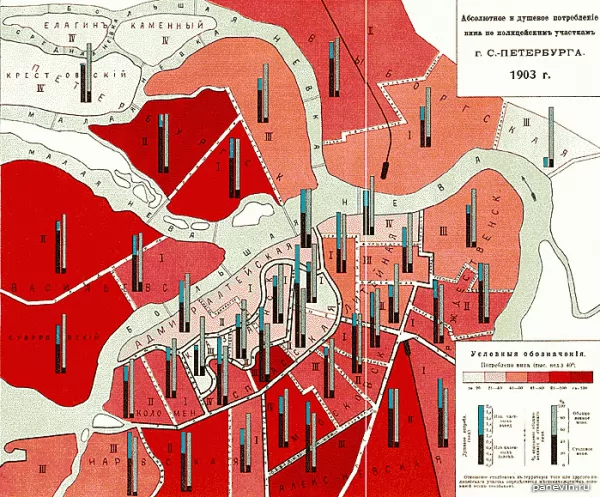
Absolute and per capita consumption of wine by police stations in St. Petersburg, 1903 .
Several metro stations are missing. Axonometric plan with major points of interest.


Absolute and per capita consumption of wine by police stations in St. Petersburg, 1903 .
t-peterburga_xviii-xix_1024-2.jpg" target="_blank">

1698 year

The city of Nien and the Swedish fortress Nyenskans. Peter I ordered to destroy this fortress, and to lay a new one closer to the bay on Hare Island.

Plan of St. Petersburg, 1705 year. Nevsky Prospect does not yet exist, but the first city buildings have already been mapped. There is also the Novgorod tract and the path to the Winter Palace and the Admiralty along the banks of the Neva .

Plan of St. Petersburg 1710s. From the collection of the Stockholm Royal Military Archives

Map of St. Petersburg compiled in 1717 by Nicolas de Fer. The border of the city is Moika, between Moika and Fontanka has not yet been built up.

Saint Petersburg map. 1720 year.

Saint Petersburg map. 1725 year. Saint Petersburg map.

1725 year. Saint Petersburg map.

1730 year. The way Vasilievsky Island is "lined" - these are plans, they will be embodied in a slightly different form. Saint Petersburg map.

1737 year. The area between Moika and Fontanka is inhabited, but it continues to be so deserted that Pastor Kreutz, in his petition to the Empress Anna Ioannovna, pointed out: “I am afraid of a lack of water, intruders, murderers, thieves and various vicissitudes that usually happen to those who live far away from their neighbors. "

1744, topographic map of Petropolis (yes, this name was also used). From the middle of the 18th century, Fontanka became the border of the city . Fragment of the "Plan of the capital city of St. Petersburg with the image of the most notable avenues thereof." Compiled by I.F.Truskott and others, engravers I. Sokolov and others, artist M.I.Makhaev (St. Petersburg, 1753

1753 year). The defensive fortifications and ditches around the Admiralty are clearly visible, it was immediately planned not only as a shipyard, but also as a fortress blocking the passage of Swedish ships to the fortress of St. Petersburg. The Swedes didn't bother. The fortifications will be finally removed and the ditches will be filled in a century later, when the Alexander Gardens will be laid out on the esplanade in front of the Admiralty under the leadership of Karl Rossi and the surrounding area will be ennobled. Also noteworthy is the pontoon Isaakievsky bridge, built during navigation.


1825 year Neva although it is indicated, it is not permanent, but floating. Isaac's Cathedral is still the previous one - the third, and the Admiralty and Kazan Cathedral are already present and the construction of the Exchange completed the Strelka ensemble of Vasilyevsky Island . The Smolny Cathedral already exists, but it will be completed and consecrated in 10 years, in 1835 .

The year is 1776 . New plan of the capital city and the fortress of St. Petersburg. Plan of the capital city of St. Petersburg. Engraver A. Savinkov (St. Petersburg, 1825 ). Liteiny bridge across the Neva

Saint Petersburg map. 1840 year. Notable changes - the Obvodny Canal appeared on the map, opened for shipping in 1835. Saint Petersburg map. 1840, legend 1. Map of St. Petersburg. 1840, legend 2.


Saint Petersburg map. 1840, legend 3.

Map of St. Petersburg. 1858 year.

Map of St. Petersburg. 1858, explanations of the plan.

Saint Petersburg map. 1859 year. Troitsky and Dvortsovy bridges, which will be built in 1903 and 1917, respectively, are surprising.

From the Guide to Russian Railways, 1867 . 1893 year. There is already a permanent Liteiny Bridge, opened in 1879.

1898 year.

1898
Bonus XX century and modernity:

1903.

1904 year.

Taxi plan 1913 year. There are already permanent bridges across the Neva: Liteiny, Blagoveshchensky, Troitsky, but the Palace is not yet, it will begin to be built in the next 1914, and instead of it there is still a pontoon Isaac Bridge (from Senate Square to Vasilyevsky Island ).

1940 year.

A modern map, well, almost. Several metro stations are missing. Axonometric plan with major points of interest.


Absolute and per capita consumption of wine by police stations in St. Petersburg, 1903 .
Share:
Themes: maps 1 St.-Petersburg 119
Ticket sales through JetRadar.com service without commissions and markups.
← Blog
Modern photo St.-Petersburg.
plani_i_karti_sankt-peterburga_xviii-xix
blog


